UG Minor Core Course or MIC-5 Human Geography (Theory) Questions Paper 2025 (Patliputra University Patna)

UG Minor Core Course or MIC-5

Human Geography (Theory)

Questions Paper 2025


(Patliputra University Patna)

UG Minor Core Course or MIC-5

UG (Regular) (Sem.-V)

Examination, 2025

(Session : 2023-27)

(MIC-5: MINOR CORE COURSE)

GEOGRAPHY

Paper Code : 420809

(Human Geography)

Time: Three Hours] [Maximum Marks: 70

Note: Candidates are required to give their answers in their own words as far as practicable. The figures in the margin indicate full marks. Answer from all parts as directed.

परीक्षार्थी यथासम्भव अपने शब्दों में ही उत्तर दें। उपांत के अंक पूर्णांक के द्योतक हैं। निर्देशानुसार सभी भागों से उत्तर दीजिए।

Part-A / भाग-अ

(Multiple Choice Questions)

(बहुविकल्पीय प्रश्न)

Note: Choose the correct option from each question:

प्रत्येक प्रश्न से सही विकल्प का चयन कीजिए [10×2=20]

1. (i) The Demographic Transition Model (DTM) describes the transition of a population from:

(a) High birth and high death rates to low birth and low death rates

(b) High birth and low death rates to low birth and high death rates

(c) Low birth rates and high death rates to high birth rates and high death rates

(d) Zero population growth to population decline

जनसांख्यिकी संक्रमण मॉडल (डीटीएम) जनसंख्या के संक्रमण का वर्णन करता है:

(a) उच्च जन्म और उच्च मृत्यु दर से निम्न जन्म और निम्न मृत्यु दर तक

(b) उच्च जन्म और निम्न मृत्यु दर से निम्न जन्म और उच्च मृत्यु दर तक

(c) निम्न जन्म दर और उच्च मृत्यु दर से उच्च जन्म दर और उच्च मृत्यु दर तक

(d) शून्य जनसंख्या वृद्धि से जनसंख्या में गिरावट तक

(ii) Which of the following regions has the highest population growth rate currently?

(a) Europe

(b) North America

(c) Sub-Saharan Africa

(d) East Asia

वर्तमान में निम्नलिखित में से किस क्षेत्र की जनसंख्या वृद्धि दर सबसे अधिक है?

(a) यूरोप

(b) उत्तरी अमेरिका

(c) उप-सहारा अफ्रीका

(d) पूर्वी एशिया

(iii) Population distribution is most influenced by which of the following factors?

(a) Economic development and access to education

(b) Climate and geographic features

(c) Political boundaries

(d) Religious and cultural affiliations

जनसंख्या वितरण निम्नलिखित में से किस कारक से सबसे अधिक प्रभावित होता है?

(a) आर्थिक विकास और शिक्षा तक पहुँच

(b) जलवायु और भौगोलिक विशेषताएँ

(c) राजनीतिक सीमाएँ

(d) धार्मिक और सांस्कृतिक सम्बद्धताएँ

(iv) Which of the following is a characteristic of forced migration?

(a) Voluntary movement based on economic opportunity

(b) Movement due to social or political factors such as war or persecution

(c) Migration for educational purposes

(d) Migration influenced by environmental changes like climate

निम्नलिखित में से कौन-सी जबरन प्रवास की विशेषता है?

(a) आर्थिक अवसर पर आधारित स्वैच्छिक प्रवास

(b) युद्ध या उत्पीड़न जैसे सामाजिक या राजनीतिक कारकों के कारण प्रवास

(c) शैक्षिक उद्देश्यों के लिए प्रवास

(d) जलवायु जैसे पर्यावरणीय परिवर्तनों से प्रभावित प्रवास

Which of the following best describes “urbanization”?

(a) The movement of people from rural areas to urban areas

(b) The movement of people from urban areas to rural areas

(c) The decline in population in both rural and urban areas

(d) The increase in population growth in rural areas

निम्नलिखित में से कौन-सा “शहरीकरण” का सबसे अच्छा वर्णन करता है?

(a) ग्रामीण क्षेत्रों से शहरी क्षेत्रों की ओर लोगों का आवागमन

(b) शहरी क्षेत्रों से ग्रामीण क्षेत्रों की ओर लोगों का आवागमन

(c) ग्रामीण और शहरी दोनों क्षेत्रों में जनसंख्या में गिरावट

(d) ग्रामीण क्षेत्रों में जनसंख्या वृद्धि दर में वृद्धि

(vi) Which of the following is a characteristic of a dispersed rural settlement?

(a) High density of houses close together

(b) Houses scattered over a wide area

(c) Settlements clustered around a market

(d) Linear arrangements along roads

निम्नलिखित में से कौन-सी एक बिखरी हुई ग्रामीण बस्ती की विशेषता है?

(a) एक दूसरे के करीब स्थित घरों का उच्च घनत्व

(b) विस्तृत क्षेत्र में फैले हुए घर

(c) बाजार के चारों ओर बसी बस्तियाँ

(d) सड़कों के किनारे रैखिक व्यवस्था

(vii) Urban settlements are often classified based on their main function. Which of the following is not a typical urban settlement function?

(a) Administrative

(b) Defence

(c) Fishing Village

(d) Industrial

शहरी बस्तियों को अक्सर उनके मुख्य कार्य के आधार पर वर्गीकृत किया जाता है। निम्नलिखित में से कौन-सा शहरी बस्तियों का विशिष्ट कार्य नहीं है?

(a) प्रशासनिक

(b) रक्षा

(c) मछली पकड़ने वाला गाँव

(d) औद्योगिक

(viii) A compact pattern of rural settlement is most likely found in areas with:

(a) Scarce Water

(b) Fertile Plains

(c) Steep Slope

(d) Dense Forest

ग्रामीण बस्तियों का एक सघन पैटर्न संभवतः निम्नलिखित क्षेत्रों में पाया जाता है:

(a) दुर्लभ जल

(b) उपजाऊ मैदान

(c) खड़ी ढलान

(d) घना जंगल

(ix) A ‘hamlet’ refers to:

(a) A Small rural Community

(b) A large Urban Centre

(c) An Industrial Town

(d) A Suburban Area

‘हैमलेट’ का तात्पर्य है:

(a) एक छोटा ग्रामीण समुदाय

(b) एक बड़ा शहरी केंद्र

(c) एक औद्योगिक शहर

(d) एक उपनगरीय क्षेत्र

(x) Which factor does not influence the site of a settlement?

(a) Relief

(b) Water Availability

(c) Soil Quality

(d) Neighbourhood

कौन-सा कारक किसी बस्ती के स्थल को प्रभावित नहीं करता है?

(a) भू-आकृति

(b) जल उपलब्धता

(c) मृदा गुणवत्ता

(d) आस-पड़ोस

Part-B / भाग-ब

(Short Answer Type Questions)

(लघु उत्तरीय प्रश्न)

Note: Answer any four questions of the following: [4×5=20]

निम्नलिखित में से किन्हीं चार प्रश्नों के उत्तर दीजिए :

2. Define Human Geography. Discuss its nature and scope with suitable examples.

मानव भूगोल की परिभाषा दीजिए। इसके स्वरूप और क्षेत्र का वर्णन उदाहरण सहित कीजिए।

3. Explain the concept of Determinism in Human Geography. Give examples to support your answer.

मानव भूगोल में निश्चयवाद की अवधारणा स्पष्ट कीजिए। अपने उत्तर की पुष्टि उदाहरण देकर कीजिए।

4. Explain the main components of population composition and their significance in human geography.

जनसंख्या संरचना के प्रमुख घटकों और मानव भूगोल में उनके महत्व की व्याख्या कीजिए।

5. Explain the stages of the Demographic Transition Theory and relate them to development.

जनसांख्यिकीय संक्रमण सिद्धान्त की अवस्थाओं की व्याख्या कीजिए और उन्हें विकास से जोड़िए।

6. Classify the main types of rural settlement patterns and explain their spatial characteristics.

ग्रामीण बस्ती के प्रमुख प्रतिरूपों का वर्गीकरण कीजिए तथा उनके स्थानिक गुणों का वर्णन कीजिए।

7. On what basis are urban settlements classified in India? Give examples of each type.

भारत में नगरीय बस्तियों का वर्गीकरण किन आधारों पर किया जाता है? प्रत्येक प्रकार का उदाहरण दीजिए।

Part-C / भाग-स

(Long Answer Type Questions)

(दीर्घ उत्तरीय प्रश्न)

Note: Answer any three questions of the following: [3×10=30]

निम्नलिखित में से किन्हीं तीन प्रश्नों के उत्तर दीजिए:

8. Explain the trends and patterns of population growth in the world since 1900. Discuss factors responsible for spatial and temporal variations in growth rates.

1900 के बाद विश्व में जनसंख्या वृद्धि के रुझानों और प्रतिरूपों की व्याख्या कीजिए। वृद्धि दरों में स्थानिक तथा कालिक विभिन्नताओं के कारणों पर वर्णन कीजिए।

9. Describe the basis of classification of urban settlements in India and describe the functional categories of towns and cities with suitable examples.

भारत में नगरीय बस्तियों के वर्गीकरण के आधारों का वर्णन कीजिए तथा उपयुक्त उदाहरणों सहित शहरों और कस्बों के कार्यात्मक वर्गों का वर्णन कीजिए।

10. Explain the major types of settlement patterns found in rural areas. Discuss the physical and socio-economic factors responsible for their formation.

ग्रामीण क्षेत्रों में पाई जाने वाली प्रमुख बस्ती प्रतिरूपों की व्याख्या कीजिए। इनके निर्माण के लिए जिम्मेदार भौतिक तथा सामाजिक-आर्थिक कारकों पर चर्चा कीजिए।

11. Explain the causes of migration and analyse its social, economic, and environmental consequences on both source and destination areas.

प्रवासन के कारणों की व्याख्या कीजिए और प्रेषक (स्रोत) तथा गंतव्य (जाने वाले क्षेत्र) क्षेत्रों पर इसके सामाजिक, आर्थिक और पर्यावरणीय प्रभावों का विश्लेषण कीजिए।

12. Describe the Demographic Transition Theory in detail. How does it help to explain the relationship between population growth and economic development?

जनसांख्यिकीय संक्रमण सिद्धान्त का विस्तारपूर्वक वर्णन कीजिए। यह सिद्धान्त जनसंख्या वृद्धि और आर्थिक विकास के सम्बन्ध को कैसे स्पष्ट करता है?


UG (Regular) (Sem.-V)

Examination, 2025

(Session: 2023-27)

(MIC-6: MINOR CORE COURSE)

GEOGRAPHY

Paper Code : 420810

(Geography of India and Bihar)

Time: Three Hours] [Maximum Marks : 70

Note: Candidates are required to give their answers in their own words as far as practicable. The figures in the margin indicate full marks. Answer from all the parts as directed.

परीक्षार्थी यथासंभव उत्तर अपने शब्दों में ही दें। उपांत के अंक पूर्णांक के द्योतक हैं। निर्देशानुसार सभी भागों से प्रश्नों के उत्तर दीजिए।

PART-A / भाग-अ

(Objective Type Questions)

(वस्तुनिष्ठ प्रश्न)

Note : Attempt all Multiple choice question from this part.

Each question carries 2 marks. [10×2=20]

इस भाग से सभी बहुविकल्पीय प्रश्नों को हल कीजिए। प्रत्येक प्रश्न 2 अंक का है।

1. (i) The Northern Plains of India are mainly formed by which process?

(a) Volcanic activity

(b) Alluvial deposition

(c) Tectonic uplift

(d) Wind erosion

भारत के उत्तरी मैदान मुख्यतः किस प्रक्रिया से बने हैं?

(a) ज्वालामुखीय क्रिया

(b) जलोढ़ निक्षेपण

(c) भू-तापीय उत्थान

(d) पवन अपरदन

(ii) Which of the following rivers is a Peninsular River?

(a) Ganga

(b) Yamuna

(c) Godavari

(d) Ghaghara

निम्नलिखित में कौन-सी एक प्रायद्वीपीय नदी है?

(a) गंगा

(b) यमुना

(c) गोदावरी

(d) घाघरा

(iii) The main cause of monsoon in India is:

(a) Westerlies

(b) Trade winds and differential heating

(c) Sea breeze

(d) Local winds

भारत में मानसून का मुख्य कारण क्या है?

(a) पश्चिमी पवनें

(b) व्यापारिक पवनें और भिन्न तापन

(c) समुद्री हवा

(d) स्थानीय पवनें

(iv) Which type of soil covers the largest area in India?

(a) Red soil

(b) Black soil

(c) Alluvial soil

(d) Laterite soil

भारत में कौन-सी मिट्टी सबसे बड़े क्षेत्र में पाई जाती है?

(a) लाल मिट्टी

(b) काली मिट्टी कपाल

(c) जलोढ़ मिट्टी

(d) लेटराइट मिट्टी

(v) Tropical evergreen forests are mainly found in:

(a) Western Ghats

(b) Thar Desert

(c) Gangetic Plain

(d) Ladakh

सदाबहार वन मुख्यतः कहाँ पाए जाते हैं:

(a) पश्चिमी घाट

(b) थार मरुस्थल

(c) गंगीय मैदान

(d) लदाख

(vi) Which state is the largest producer of jute in India?

(a) Bihar

(b) Assam

(c) West Bengal

(d) Odisha

भारत में जूट का सबसे बड़ा उत्पादक राज्य कौन-सा है?

(a) बिहार

(b) असम

(c) पश्चिम बंगाल

(d) ओडिसा

(vii) The sugar industry in India is mainly located in:

(a) Punjab

(b) Maharashtra and Uttar Pradesh

(c) Tamil Nadu

(d) Gujarat

भारत में चीनी उद्योग मुख्यतः कहाँ स्थित है?

(a) पंजाब

(b) महाराष्ट्र और उत्तर प्रदेश

(c) तमिलनाडु

(d) गुजरात

(viii) The North Bihar plain is frequently affected by:

(a) Earthquake

(b) Flood

(c) Drought

(d) Landslide

उत्तर बिहार का मैदान प्रायः किससे प्रभावित रहता है?

(a) भूकम्प

(b) बाढ़

(c) सूखा

(d) भूस्खलन

(ix) Which of the following rivers flows through Bihar?

(a) Krishna

(b) Mahanadi

(c) Kosi

(d) Godavari

निम्नलिखित में से कौन-सी नदी बिहार से होकर बहती है?

(a) कृष्णा

(b) महानदी

(c) कोसी

(d) गोदावरी

(x) The physiography of Bihar mainly consists of:

(a) Plateau and Desert

(b) Northern plains and Southern plateau

(c) Coastal plain

(d) Hill ranges only

बिहार की भौतिक संरचना मुख्यतः किन भागों से मिलकर बनी है:

(a) पठार और मरुस्थल

(b) उत्तरी मैदान और दक्षिणी पठार

(c) तटीय मैदान

(d) केवल पर्वत श्रृंखलाएँ

PART-B / भाग-ब

(Short Answer Type Questions)

(लघु उत्तरीय प्रश्न)

Note : Answer any four questions. Each question carries 5 marks. [4×5=20]

निम्नलिखित में से किन्हीं चार प्रश्नों के उत्तर दीजिए। प्रत्येक प्रश्न 5 अंकों का है।

2. Describe the main physiographic divisions of India.

भारत के प्रमुख भौतिक (स्थलाकृतिक) विभाजनों का वर्णन कीजिए।

3. Compare the characteristics of Himalayan and Peninsular rivers.

हिमालयी और प्रायद्वीपीय नदियों की विशेषताओं की तुलना कीजिए।

4. Explain the origin and mechanism of the Indian monsoon.

भारतीय मानसून की उत्पत्ति और तंत्र (प्रक्रिया) की व्याख्या कीजिए।

5. Write a short note on the types and distribution of soils in India.

भारत में मिट्टियों के प्रकार और वितरण पर संक्षिप्त टिप्पणी लिखिए।

6. Discuss the geographical factors responsible for the growth of the sugar industry in India.

भारत में चीनी उद्योग के विकास के लिए उत्तरदायी भौगोलिक कारकों पर चर्चा कीजिए।

7. Describe the structure and physiography of Bihar and its impact on agriculture.

बिहार की संरचना और भौगोलिक बनावट का वर्णन कीजिए तथा कृषि पर इसके प्रभाव को स्पष्ट कीजिए।

PART-C/ भाग-स

(Long Answer Type Questions)

(दीर्घ उत्तरीय प्रश्न)

Note: Answer any three questions. Each question carries 10 marks. [3×10=30]

निम्नलिखित में से किन्हीं तीन प्रश्नों के उत्तर दीजिए। प्रत्येक प्रश्न 10 अंकों का है।

8. Describe in detail the relief and geological structure of India. How do these physical features influence the distribution of population and economic activities?

भारत की उच्चावच और भूवैज्ञानिक संरचना का विस्तार से वर्णन कीजिए। ये भौतिक विशेषताएँ जनसंख्या वितरण और आर्थिक गतिविधियों को किस प्रकार प्रभावित करती हैं?

9. Discuss the origin, mechanism and characteristics of the Indian monsoon. Explain its importance for Indian agriculture?

भारतीय मानसून की उत्पत्ति, क्रियाविधि और विशेषताओं पर चर्चा कीजिए। भारतीय कृषि के लिए इसके महत्व को स्पष्ट कीजिए।

10. Explain the different types of natural vegetation found in India and the factors responsible for their distribution.

भारत में पाई जाने वाली विभिन्न प्रकार की प्राकृतिक वनस्पतियों तथा उनके वितरण के लिए उत्तरदायी कारकों की व्याख्या कीजिए।

11. Describe the Sugar and Paper agricultural industries of India. Discuss the geographical conditions required for their growth and development.

भारत के चीनी और कागज कृषि उद्योगों का वर्णन कीजिए। इनके विकास और वृद्धि के लिए आवश्यक भौगोलिक परिस्थितियों पर चर्चा कीजिए।
14. Correlation analysis (सहसंबंध विश्लेषण)

Correlation analysis

(सहसंबंध विश्लेषण)


⇒ Correlation analysis deals with the association between two or more Variables.

⇒ The degree of relationship between the Variables Under consideration is measured through the correlation analysis.

⇒ The measure of correlation called the “Correlation coefficient or correlation index” Summarizes in Figure the direction & degree one of correlation.

Example1

x⇑ y⇑
10 15
12 20
15 22
18 25
20 37
25 43

👉  ऊपर दिए गए आँकड़ों में x और y के मानों को देखने पर स्पष्ट होता है कि जैसे-जैसे x का मान बढ़ता है, वैसे-वैसे y का मान भी बढ़ रहा है।

👉  अर्थात्, x में वृद्धि होने पर y में भी वृद्धि की प्रवृत्ति दिखाई देती है, जिससे दोनों चर आपस में सकारात्मक रूप से संबंधित हैं।

👉 यहाँ x और y के बीच धनात्मक (Positive) सहसंबंध है।

Example2

x⇑ y⇓
20 40
30 30
40 22
50 15
60 10
80 4

👉  दिए गए आँकड़ों में जैसे-जैसे x का मान बढ़ता है, वैसे-वैसे y का मान घटता जाता है।

👉  अतः x और y के बीच नकारात्मक (ऋणात्मक) सहसंबंध पाया जाता है।

👉  चूँकि परिवर्तन नियमित और स्पष्ट है, इसलिए यह प्रबल नकारात्मक सहसंबंध (Strong Negative Correlation) को दर्शाता है।

Type of Correlation

1. Positive Correlation (Direct Correlation):-

   If both the Variable in Same direction. x⇑, y⇑ or x⇓, y⇓ e.g., Height & Weight, Rainfall & Yeild

2. Negative Correlation (Inverse Correlation):-

    If both the variables Varies in opposite direction. x⇑, y⇓ or x⇓, y⇑ e.g., Price & Demand

3. Zero Correlation (No Correlation):-

      When there is no relationship between variables. or When one variable changes, the other variable does not change in any consistent way. x⇑⇓, y or x, y⇑⇓ e.g., Shoe size & intelligence

Correlation Coefficient (r)

     The correlation coefficient is a statistical measure that shows the strength and direction of the relationship between two variables. Its value ranges from −1 to +1, where positive values indicate direct correlation, negative values indicate inverse correlation, and zero indicates no relationship.

r = +1 ⇒ Perfect Positive Correlation,

r = -1 ⇒ Perfect Negative Correlation,

r = 0 ⇒ No Relation,

r = 0.8, 0.9, 0.95 अर्थात जब r का Value 1 के करीब आता है तो उसे Strong +ve Correlation कहा जाता है।

r = -0.85, -0.9, -0.95 अर्थात जब r का Value लगभग -1 के करीब आता है तो उसे Strong Negative Correlation कहा जाता है।

Method of Finding Correlation Coefficient (r)

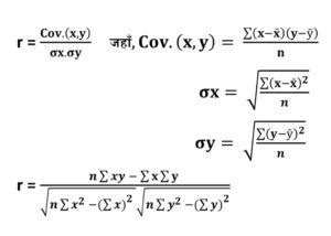
          The correlation coefficient (r) is found using several methods. The Karl Pearson’s method is the most common, where r is calculated by dividing the covariance of two variables by the product of their standard deviations.

     The Spearman’s rank correlation method is used when data are ranked or not normally distributed.

    Another method is the concurrent deviations method, suitable for time-series data showing direction of change.

             Scatter diagram method finds correlation coefficient (r) by plotting paired data points, observing pattern direction, and estimating strength visually.

   These methods help measure the degree and direction of relationship between variables, with values of r ranging from –1 to +1.

1. Karl Pearson’s method

2. Spearman’s rank correlation method

3. Concurrent deviations method

4. Scatter diagram method

1. Karl Pearson’s Product Moment Method

      Karl Pearson’s Product Moment Method measures the degree and direction of linear relationship between two quantitative variables. It uses covariance divided by the product of their standard deviations, producing a correlation coefficient (r) ranging from –1 to +1, indicating negative, positive, or no correlation.


Ex. (i) Find coefficient of correlation of the following data.

x y
9 15
8 16
7 14
6 13
5 11
4 12
3 10
2 8
1 9

Solution:

x y x2 y2 xy
9 15 81 225 135
8 16 64 256 128
7 14 49 196 98
6 13 36 169 78
5 11 25 121 55
4 12 16 144 48
3 10 9 100 30
2 8 4 64 16
1 9 1 81 9
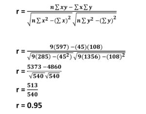
Total sum = 45 108 285 1356 597

n = No. of pair of observers

n = 9

Σxy = 597

Σx = 45

Σy = 108

Σx2 = 285

Σy2 = 1356

Correlation analysis

UG MIC1 Geography Examination 2025 Patliputra University, Patna

UG MIC1 Geography Examination 2025 

Patliputra University, Patna


UG MIC1 Geography Examination 2025 

UG (Regular) (Sem.-I) Examination, 2025

(Session: 2025-29)

(MIC-1: MINOR CORE COURSE)

GEOGRAPHY

Paper Code : 420801

(Geomorphology)

Time: Three Hours] [Maximum Marks: 70

Note: Candidates are required to give their answers in their own words as far as practicable. The figures in the margin indicate full marks. Answer from all sections as directed.

परीक्षार्थी यथासम्भव अपने शब्दों में ही उत्तर दें। उपांत के अंक पूर्णांक के द्योतक हैं। निर्देशानुसार सभी खण्डों से उत्तर दीजिए।

Section-A / खण्ड-अ

(Objective Type Questions)

(वस्तुनिष्ठ प्रश्न)

Note : Choose the correct option from each question:

1. प्रत्येक प्रश्न से सही विकल्प का चयन कीजिए: [10×2=20]

(i) Who proposed the Gaseous Hypothesis of the origin of the Earth?

(a) Immanuel Kant

(b) Pierre-Simon Laplace

(c) George Buffon

(d) James Jeans

पृथ्वी की उत्पत्ति की गैसीय परिकल्पना किसने प्रतिपादित की?

(a) इमैनुअल कांट

(b) पियरे साइमन लाप्लास

(c) जॉर्ज बफन

(d) जेम्स जीन्स

(ii) The boundary between the crust and the mantle is known as

(a) Gutenberg Discontinuity

(b) Mohorovicic Discontinuity

(c) Conrad Discontinuity

(d) Lehmann Discontinuity

भूपटल और मेंटल के बीच की सीमा को क्या कहा जाता है?

(a) गुटेनबर्ग विस्मयता

(b) मोहोरोविकिक विस्मयता

(c) कॉनराड विस्मयता

(d) लेहमैन विस्मयता

(iii) Which waves cannot pass through the Earth’s outer core?

(a) S-waves

(b) P-waves

(c) Surface waves

(d) Both (a) and (b)

पृथ्वी की बाह्य कोर से कौन-सी तरंगे नहीं गुजर सकती?

(a) एस-तरंगे

(b) पी-तरंगे

(c) सतही तरंगे

(d) दोनों (a) और (b)

(iv) Which of the following is not true about seismic waves?

(a) P-waves can pass through solids, liquids, and gases

(b) S-waves can travel only through solids

(c) P-waves travel slower than S-waves

(d) The speed of seismic waves increases with depth in the mantle

निम्नलिखित में से कौन-सा कथन भूकंपीय तरंगों के बारे में सही नहीं है?

(a) पी-तरंगे ठोस, द्रव और गैसों से गुजर सकती हैं

(b) एस-तरंगे केवल ठोस माध्यमों से यात्रा कर सकती हैं

(c) पी-तरंगें एस-तरंगों से धीमी गति से चलती हैं

(d) मेंटल की गहराई के साथ भूकंपीय तरंगों की गति बढ़ती है

(v) Which of the following is an endogenic geomorphic process?

(a) Weathering

(b) Deposition

(c) Erosion

(d) Earthquake

निम्नलिखित में से कौन-सी एक अंतर्जात भू-पृष्ठीय प्रक्रिया है?

(a) अपक्षय

(b) निक्षेपण

(c) कटाव

(d) भूकंप

(vi) Which rock is formed from the cooling of lava on the Earth’s surface?

(a) Basalt

(b) Marble

(c) Gneiss

(d) Shale

पृथ्वी की सतह पर लावा के ठंडा होने से बनी शिला कौन-सी है?

(a) बेसाल्ट

(b) संगमरमर

(c) ग्नाइस/ग्निस

(d) शेल

(vii) The process of formation of landforms due to internal forces is known as:

(a) Denudation

(b) Gradation

(c) Diastrophism

(d) Mass wasting

आंतरिक बलों द्वारा स्थल के निर्माण की प्रक्रिया को कहते हैं:

(a) अनाच्छादन

(b) समकोटिकरण

(c) पटलविरूपण

(d) गुरुत्वीय ढलान क्रिया

(viii) Gully erosion is most commonly associated with:

(a) Glacial movement

(b) Deflation

(c) Running water

(d) Earthquakes

गली अपरदन सामान्यतः किससे जुड़ा होता है?

(a) हिमानी संचलन

(b) अपक्षारण

(c) बहता जल

(d) भूकम्प

(ix) The Benioff Zone is associated with:

(a) Volcanic arcs at divergent margins

(b) Earthquake zones at subduction boundaries

(c) Mantle plume zones

(d) Sea-floor spreading centres

बेनिऑफ जोन किससे सम्बन्धित है?

(a) डायवर्जेंट सीमाओं पर ज्वालामुखी चाप

(b) सबडक्शन सीमाओं पर भूकंपीय क्षेत्र

(c) मेंटल प्लूम क्षेत्र

(d) समुद्र तल प्रसारण केन्द्र

(x) Which volcanic landforms results from a collapsed magma chamber after a major eruption?

(a) Composite cone

(b) Lava dome

(c) Shield volcano

(d) Caldera

प्रचंड विस्फोट के बाद मैग्मा चैंबर के ढहने से बनने वाली आकृति है:

(a) मिश्रित शंकु

(b) लावा गुंबद

(c) शील्ड ज्वालामुखी

(d) काल्डेरा

Section-B / खण्ड-ब

(Short Answer Type Questions)

(लघु उत्तरीय प्रश्न)

Note: Answer any four questions of the following: [4×5=20]

निम्नलिखित में से किन्हीं चार प्रश्नों के उत्तर दीजिए

2. Describe the internal structure of the Earth with a labelled diagram.

पृथ्वी की आंतरिक संरचना का संक्षिप्त वर्णन कीजिए।

3. What is the Gaseous Hypothesis regarding the origin of the Earth? Explain its main features.

पृथ्वी की उत्पत्ति से सम्बन्धित गैसीय परिकल्पना क्या है? इसके मुख्य विशेषताओं की व्याख्या कीजिए।

4. How are Sedimentary rocks formed? Give examples.

अवसादी चट्टानें कैसे बनती हैं? उदाहरण सहित समझाइए।

5. Differentiate between intrusive and extrusive volcanic
landforms with examples.

उदाहरण सहित अंतःनवनीय और बहिःनवनीय ज्वालामुखी स्थलरूपों में अन्तर स्पष्ट कीजिए।
6. What are Earthquakes? Describe their causes and types.

भूकम्प क्या है? इनके कारणों एवं प्रकारों का वर्णन कीजिए।

7. Differentiate between convergent, divergent and transform plate boundaries with suitable diagrams.

उचित आरेखों सहित अभिसारी, अपसारी और रूपांतरण प्लेट सीमाओं में अन्तर स्पष्ट कीजिए।

Section-C / खण्ड-स

(Long Answer Type Questions)

(दीर्घ उत्तरीय प्रश्न)

Note: Answer any three questions of the following: [3×10=30]

निम्नलिखित में से किन्हीं तीन प्रश्नों के उत्तर दीजिए:

8. Explain the Binary Star hypothesis about the origin of the Earth and the solar system.

पृथ्वी और सौरमंडल की उत्पत्ति के बारे में द्वितारा परिकल्पना की व्याख्या कीजिए।

9. What is Weathering? Describe the different types of weathering with suitable examples.

अपक्षय क्या है? अपक्षय के विभिन्न प्रकारों को उदाहरण सहित समझाइए।

10.What is a Volcano? Describe the types of volcanoes based on eruption style.

ज्वालामुखी क्या होता है? उद्गार शैली के आधार पर ज्वालामुखियों के प्रकारों को समझाइए।

11. Explain the major erosional landforms formed by the wind.

पवन द्वारा निर्मित अपरदनकारी भू-आकृतियों की व्याख्या कीजिए।

12. What is the Plate Tectonics theory? Explain its major features.

प्लेट विवर्तनिकी सिद्धान्त क्या है? इसकी मुख्य विशेषताओं की व्याख्या कीजिए। 

UG Regular Semester-I Examination 2025 Patliputra University, Patna QUESTION PAPER

UG Regular Semester-I Examination 2025

Patliputra University, Patna

QUESTION PAPER


UG Regular Semester-I Examination 2025

(Major Core Course or MJC-1)

(Session: 2025-29)

Paper Code : 410801

Geomorphology (Theory)

Time: Three Hours] [Maximum Marks: 70

Note : Candidates are required to give their answers in their own words as far as practicable. The figures in the margin indicate full marks. Answer from all the sections as directed.

परीक्षार्थी यथासंभव अपने शब्दों में ही उत्तर दें। उपांत के अंक पूर्णांक के द्योतक हैं। निर्देशानुसार सभी खण्डों से उत्तर दें।

Section-A / खंड -अ

(Objective Type Questions)

(वस्तुनिष्ठ प्रश्न)

Note : Attempt all Multiple choice questions from this part. Each question carries 2 marks. [10×2=20]

इस भाग से सभी बहुविकल्पीय प्रश्नों को हल कीजिए। प्रत्येक प्रश्न 2 अंक का है।

1. Choose the correct option from each question:

प्रत्येक प्रश्न से सही विकल्प का चयन कीजिए:

(i) Which is the outermost layer of the Earth?

(a) Mantle

(b) Core
(c) Crust

(d) Lithosphere

पृथ्वी की सबसे बाहरी परत कौन-सी है?

(a) मेंटल

(b) कोर

(c) क्रस्ट

(d) स्थलमंडल

(ii) What does the Big Bang Theory explain:

(a) The end ofthe universe

(b) The structure of the Earth

(c) The origin of the universe

(d) The movement of galaxies

बिग बैंग सिद्धान्त किसकी व्याख्या करता है?

(a) ब्राह्मांड का अंत

(b) पृथ्वी का संरचना

(c) ब्रह्मांड की उत्पत्ति

(d) आकाशगंगाओं की गति

(iii) Which layer of the Earth is broken into tectonic plates?

(a) Inner Core

(b) Asthenosphere

(c) Lithosphere

(d) Mantle

पृथ्वी की कौन-सी परत विवर्तनिक प्लेटों में विभाजित होती है?

(a) आंतरिक कोर

(b) एस्थेनोस्फीयर

(c) स्थलमंडल

(d) मेंटल

(iv) The boundary where two tectonic plates move away from each other is called:

(a) Convergent boundary

(b) Transform boundary

(c) Divergent boundary

(d) Passive margin

जिस सीमा पर दो प्लेट एक-दूसरे से दूर हटती हैं? उसे क्या कहा जाता है?

(a) अभिसरण सीमा

(b) परिवर्तित सीमा

(c) अपसारी सीमा

(d) निष्क्रिय किनारा

Which of the following is a major cause of volcanic eruptions?

(a) Solar radiation

(b) Movement of tectonic plates

(c) Weathering

(d) Ocean currents

निम्नलिखित में से कौन ज्वालामुखी विस्फोट का प्रमुख कारण है?

(a) सौर विकिरण

(b) विवर्तनिक प्लेटों की गति

(c) अपक्षय

(d) समुद्री धाराएं

(vi) What is the point inside the Earth where an earthquake originates called?

(a) Epicenter

(b) Focus (Hypocenter)

(c) Fault line

(d) Seismic zone

पृथ्वी के अन्दर वह स्थान जहाँ भूकम्प की उत्पत्ति होती है, क्या कहलाता है?

(a) उपकेन्द्र

(b) केन्द्र बिन्दु

(c) अंश रेखा

(d) भूकम्पीय क्षेत्र

(vii) Karst topography is primarily formed due to the action of:

(a) Wind

(b) Glaciers

(c) Groundwater action on limestone

(d) Volcanic activity

कार्स्ट स्थलाकृति मुख्य रूप से निम्नलिखित की क्रिया के कारण बनती है:

(a) पवन

(b) हिमनद

(c) चूना पत्थर पर भूमिगत जल की क्रिया

(d) ज्वालामुखी गतिविधि

(viii) Which of the following is a depositional feature formed by glaciers?

(a) Cirque

(b) Moraine

(c) Arete

(d) U-shaped valley

निम्नलिखित में से कौन-सी स्थलरूपी संरचना हिमनदों द्वारा निक्षेपण के कारण बनती है?

(a) सर्क

(b) मोरेन

(c) एरेट

(d) यू-आकार की घाटी

(ix) Which of the following landforms is commonly found in arid regions?

(a) Cirque

(b) Yardang

(c) Moeraine

(d) Delta

निम्नलिखित में से कौन-सी स्थलाकृति शुष्क क्षेत्रों में पाई जाती है?

(a) सर्क

(b) यारडांग

(c) मोरेन

(d) डेल्टा

(x) A mushroom rock is formed due to:

(a) Glacial erosion

(b) Volcanic activity

(c) Wind erosion

(d) Chemical weathering

मशरूम चट्टान किसके कारण बनती है?

(a) हिमनदी अपरदन

(b) ज्वालामुखी क्रिया

(c) पवन अपरदन

(d) रासायनिक अपक्षय

PART-B / भाग-ब

(Short Answer Type Questions)

(लघु उत्तरीय प्रश्न)

Note: Answer any four questions. Each question carries 5 marks. [4×5=20]

निम्नलिखित में से किन्हीं चार प्रश्नों के उत्तर दीजिए। प्रत्येक प्रश्न 5 अंकों का है।

2. Discuss is briefabout the scope of Geomorphology.

भू-आकृति विज्ञान के क्षेत्र पर संक्षेप में चर्चा कीजिए।

3. Discuss about the convergent plate boundary.

अभिसारी प्लेट सीमा के बारे में चर्चा कीजिए।

4. Write about the different types of volcanoes.

ज्वालामुखियों के विभिन्न प्रकारों के बारे में लिखिए।
5. Write about the difference between the Weathering and Erosion Process.

अपघटन और अपरदन की प्रक्रियाओं में क्या अंतर है? लिखिये।

6. Explain the major landforms created by glacial erosion.

हिमानी अपरदन द्वारा निर्मित प्रमुख स्थलरूपों की व्याख्या कीजिए।

What is isostasy? Discuss the postulates made by Airy or Pratt.

समस्थिति क्या है? एयरी या प्रेट द्वारा दिए गए सिद्धान्तों की चर्चा कीजिए।

PART-C/ भाग-स

(Long Answer Type Questions)

(दीर्घ उत्तरीय प्रश्न)

Note: Answer any three questions. Each question carries 10 marks. [3×10-30]

निम्नलिखित में से किन्हीं तीन प्रश्नों के उत्तर दीजिए। प्रत्येक प्रश्न 10 अंकों का है।
8. Explain the Nebular Hypothesis or Tidal Hypothesis and discuss its importance in understanding the origin of the Earth.

निहारिका सिद्धान्त अथवा ज्वारीय सिद्धान्त की व्याख्या कीजिए तथा पृथ्वी की उत्पत्ति को समझने में इसकी महत्ता पर चर्चा कीजिए।
9. Describe the internal structure of the Earth with the help of a labelled diagram.

पृथ्वी की आन्तरिक संरचना का वर्णन एक चिन्हित आरेख की सहायता से कीजिए।
10. Describe Alfred Wagener’s Continental Drift Theory.

अल्फ्रेड वेगनर के महाद्वीपीय विस्थापन सिद्धान्त का वर्णन कीजिए।
11. Explain the theory of mountain building proposed by Kober or Holmes.

कोबर या होम्स द्वारा प्रस्तुत पर्वत निर्माण सिद्धान्त की व्याख्या कीजिए।
12. Explain the Normal cycle of Erosion as proposed by William Morris Davis.

विलियम मॉरिस डेविस द्वारा प्रतिपादित सामान्य अपरदन चक्र की व्याख्या कीजिए।

17. Nearest Neighbor Analysis (निकटतम पड़ोसी विश्लेषण)

Nearest Neighbor Analysis

(निकटतम पड़ोसी विश्लेषण)


Nearest Neighbor Analysis

परिचय

    निकटतम पड़ोसी विश्लेषण (Nearest Neighbor Analysis) एक प्रकार की स्थानिक सांख्यिकीय तकनीक है जिसका उपयोग भौगोलिक प्रतिरूप, वितरण और दूरी के अध्ययन के लिए किया जाता है।

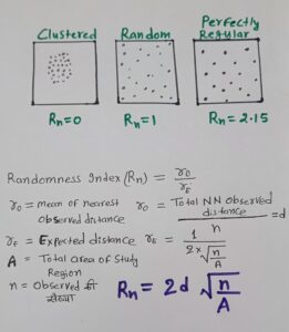
    यह विश्लेषण बताता है कि किसी वस्तु (जैसे कि शहर, पौधे, जीव, अपराध स्थल आदि) का वितरण सांख्यिकीय रूप से समूहित (Clustered), यादृच्छिक (Random) या समान (Regular/Uniform) रूप से फैलाव वाला  है या नहीं।

    भौगोलिक सूचना प्रणाली (GIS) और स्थानिक आंकड़ों के अध्ययन में यह तकनीक अत्यंत महत्वपूर्ण है क्योंकि यह स्थानिक संरचना और प्रतिरूप का वैज्ञानिक मूल्यांकन करने में मदद करती है।

उद्देश्य

    निकटतम पड़ोसी विश्लेषण के मुख्य उद्देश्य निम्नलिखित हैं:

(i) किसी वस्तु का स्थानिक वितरण पैटर्न पहचानना।

(ii) यह जांचना कि क्या वितरण यादृच्छिक, समूहित या समान रूप से फैला है।

(iii) शहरी और ग्रामीण योजना में केंद्रों की उचित व्यवस्था सुनिश्चित करना।

(iv) आर्थिक और पर्यावरणीय अध्ययन में प्राकृतिक संसाधनों के वितरण का विश्लेषण।

(v) आपदा प्रबंधन और आपूर्ति श्रृंखला योजना में उपयोग।

सिद्धांत

     निकटतम पड़ोसी विश्लेषण निम्नलिखित आधार पर कार्य करता है:

⇒ प्रत्येक बिंदु के लिए सबसे नजदीकी पड़ोसी की दूरी मापी जाती है।

⇒ इन दूरी का औसत लिया जाता है।

⇒ इसे यादृच्छिक वितरण से तुलना की जाती है।

⇒ यदि बिंदु बहुत पास-पास हैं तो सामूहिक (Clustered)

⇒ यदि बिंदु असमान हैं तो यादृच्छिक (Random)

⇒ यदि बिंदु एक समान रूप से फैले हैं तो समान (Regular/Uniform)

मुख्य सूत्र:

Rn (Randomness Index) अनुपात निकालना:

Nearest Neighbor Analysis

उपयोग

(i) शहरी योजना: विद्यालय, अस्पताल, बस स्टॉप आदि का स्थानिक वितरण समझने के लिए।

(ii) पर्यावरण अध्ययन: पौधों और जीवों का वितरण।

(iii) अपराध भूगोल: अपराध स्थलों का क्लस्टरिंग पैटर्न पहचानना।

(iv) संसाधन प्रबंधन: जल स्रोत, खनिज आदि का स्थानिक विश्लेषण।

(v) सामाजिक अध्ययन: बाजार, बैंक या अन्य सेवाओं का वितरण।

निष्कर्ष:

     निकटतम पड़ोसी विश्लेषण एक सरल परंतु शक्तिशाली तकनीक है, जो स्थानिक वितरण पैटर्न को समझने और मूल्यांकन करने में मदद करती है। यह शहरी, पर्यावरणीय, आर्थिक और सामाजिक अध्ययन में अत्यंत उपयोगी है। सही डेटा और सॉफ्टवेयर टूल के साथ, यह यादृच्छिक, समूहित और समान वितरण को स्पष्ट रूप से पहचान सकता है और नीति निर्माण और योजना में महत्वपूर्ण योगदान देता है।

error: